trendix mining

trendix mining

trendix mining

Trendix Mining una una compañía minera junior, orientada al descubrimiento de áreas con gran potencial minero dentro del territorio Argentino.
Aguilar 2547 - 18º A CABA, CABA C1426DSK Argentina
subir

Energy
Project

Bajo del
cerro Piche

Commodity
Uranium
Location
Río Negro
Argentina
Location

The BCP project is located about 30 km north of Los Menucos town, in the province of Río Negro. Access is by the paved road (provincial route Nº 8) that connects the city of General Roca with Los Menucos town.
Central point coordinates are: 40 ° 40´14 "S - 68 ° 23´10 ' W

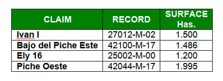
The mining properties that form the project are fully owned by Trendix SA and cover a total surface of 6,181 has.

bajo del cerro piche

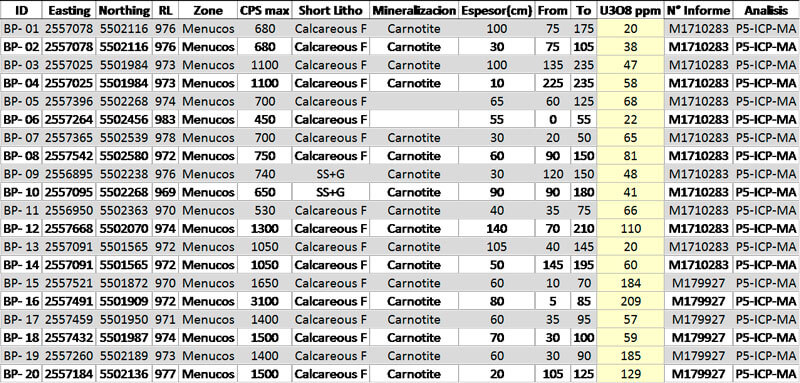
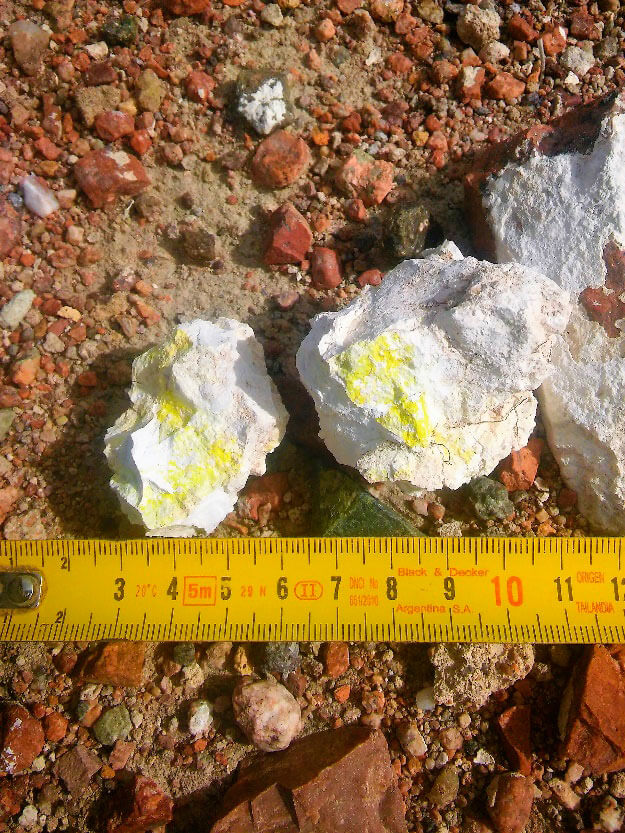
Uranium mineralization at the BCP project area, is related at silty and sandy soil levels with variable grades of develop of horizons with gypsum and carbonates accumulation. Mineralized thickness varies between 20 cm up to 1.50 m. and is developed from the surface until a depth of 2.40 m. Visible uranium mineralization is characterized by a yellow pale to brilliant (carnotite) appear disseminated in the matrix of calcareous soil either covering clasts.
Mineralization is open to the N and NW direction.

bajo del cerro piche

The age of sediments where mineralization is developed corresponds at upper Pleistoce to Holocene.

Custom Map
Project Location
Exploration

The exploration methodology consisted of detection and demarcation of abnormal points (1.5 - 2 times of background), with the use of centellometer on the field and roads. Started on the Southeast area of the Piche Graben identified like Prospect A, which encompass the calcareous sediments and occupies an area of 300 hectares.

Once demarcated the anomalous radiometric area, were dug pits with pick and shovel each 50 meters in order to verify the presence of mineralization, evaluate the soil profile and mineralization comportment. The next step was to determine the extension of the mineralized mantle making pits every 200 meters. If the result was positive stretched another 200 meters. If the result was negative the distance between pits were cut at 100 m. to verify the mineralization continuity.

In total were executed 45 pits with a total depth of 59 m. drilled and were extracted 20 samples for further analysis.

The proposal model for the exploration correspond at surface deposits that occupy geoforms of filling of valleys. In these deposits exists replacement or illuviation (defined as an accumulation process in a soil horizon of elements originated in other overlying), of calcareous material, gypsum, halite, dolomite, FeOx and MnOx in fine lithologies related at the movement of cations and anions in the vadose zone. These deposits are typically associated to Tertiary or Quaternary formations of fluvial - alluvial origin and even eolic. The uranium
mineralization is often in the form of Carnotite (K2 (UO2)2 (VO4)2 3H2O).

Uranium deposits associated with calcareous levels are the superficial deposits of larger size who are exploited today in all the world.

bajo del cerro piche
Laboratory result
for extracted samples
flecha conclusion
Conclusion

a) Mineralization is hosted in Holocene sediments that fill lows close to the surface, in the sections with abundant evaporitic minerals.
b) There is a direct relationship between the proportion of calcareous / gypsum material and the mineralization.
c) Was confirmed the presence of at least two calcareous levels.
d) Mineralization is disseminated and is occasionally visible at naked eye.
e) Mineralization thickness is higher than 50 cm and coverage varies between 20 and 120 cm.
f) Mineralization at Prospect A extends by 1,200 m x 800 m.
g) Exists a high potential to expand the continuity of mineralization in Prospect A towards the NW sector.
h) The Triassic sedimentary and volcanic deposits are not mineralized but they probably acted as a source of mineralization.